Thank you for visiting! Here you will find a selection of printable, interactive worksheets for your classroom: Basic Geography worksheets with simple maps, ESL, Spanish, Bible, Reading Comprehension and more. I hope you find the resources useful! Reviews are welcome and very much appreciated. Thank you so much.
Thank you for visiting! Here you will find a selection of printable, interactive worksheets for your classroom: Basic Geography worksheets with simple maps, ESL, Spanish, Bible, Reading Comprehension and more. I hope you find the resources useful! Reviews are welcome and very much appreciated. Thank you so much.
Introduce your students to UKRAINE with this printable handout of two worksheets (plus answer key). Your students will read a brief introduction to Ukraine (location, capital, flag, language), write 'Kiev' next to the star on the map to show the location of the capital, color the small map and flag, and use the map and compass to answer 7 questions on page 2. Colored pencils and a pen or pencil are needed for this activity. No other prep needed. Basic Geography worksheet with a simple map to introduce the Ukraine and practice cardinal and ordinal directions.
For use with Interactive Notebooks: After the worksheets are completed, students can cut out the map and flag and paste into the notebook under the topic of Europe/Sub-Topic: Ukraine. Under the map, students can write a summary in their own words of what they now know about this country. Collect worksheets for other countries of Europe to add to the notebook! All available in this store. Please browse this store for a selection of printable handouts for other countries of Europe (and beyond!).
Thank you so much for using my Geography worksheets in your classroom! I hope you find them useful. Reviews are welcome and very much appreciated!
Introduce your students to Guatemala with two printable worksheets (plus answer key). Your students will read a brief introduction to Guatemala (location, capital, flag, language), write ‘Guatemala City’ next to the star on the map to show the location of the capital, color the small flag and map, and use the map and compass to answer 7 questions on page 2. Colored pencils and a pen or pencil are needed for this activity. No other prep needed. Basic Geography worksheet with a simple map to introduce Guatemala and practice cardinal and ordinal directions.
For use with Interactive Notebooks: After the worksheets are completed, students can cut out the map and flag and paste into the notebook under the topic of Central America (or Spanish-Speaking Countries)/ Sub-Topic: Guatemala. Under the map and flag, students can write a summary in their own words about what they now know about this country. Collect worksheets for other countries to add to the notebook! Please browse this store for worksheets for other countries of Central America and beyond!!
Thank you so much for using my Geography worksheets in your classroom! I hope you find them useful. Reviews are welcome and very much appreciated. Please browse this store for worksheets to introduce your students to the countries of the world!
Libertad 15 de Septiembre de 1821, cardinal, ordinal directions, Spanish, Mexico, Belize, Honduras, El Salvador, Caribbean Sea, Pacific Ocean.
This printable handout includes 10 ‘fill in the blank’ questions with a Word Bank to review Chapter 1 of ‘Tales of a Fourth Grade Nothing’ by Judy Blume.
For the complete packet of handouts for every chapter, please visit https://www.tes.com/teaching-resource/tales-of-a-fourth-grade-nothing-by-judy-blume-printable-handouts-for-each-chapter-11886566
Thank you!!
Introduce your students to the country of JORDAN with two worksheets (plus answer key). Your students will read a brief introduction to Jordan (location, capital, language, flag), write ‘Amman’ next to the star on the map to show the location of the capital, color the small map, and use the map and compass to answer 9 questions on page 2. Colored pencils and a pen or pencil are needed for this activity. No other prep needed. Basic Geography worksheet with a simple map to introduce Jordan and practice cardinal/ordinal directions.
For use with Interactive Notebooks: After the worksheets are completed, students can cut out the map and flag an paste into the notebook under the topic of Asia or Middle East /Sub-topic: Jordan. Under the map, your students can write a summary in their own words of what they now know about this country. Collect worksheets for other countries of Asia or Middle East to add to the notebook! All available in this store. Please browse this store for a selection of printable Geography worksheets for other countries of Asia, Middle East and beyond!
Thank you so much for using my Geography worksheets in your classroom! I hope you find them useful. Reviews are welcome and very much appreciated!
Hashemite Kingdom of Jordan, Western Asia, Middle East, Saudi Arabia, Iraq, Syria, Israel, Palestinian West Ban, Dead Sea, Red Sea, Amman, Arabic, Pan-Arab, Al-Fatiha
Introduce your learners to the Bahamas with two worksheets (plus answer key). Your students will read a brief introduction to the Bahamas (location, capital, flag, islands), write ‘Nassau’ next to the star on the map on New Providence to show the location of the capital, color the map, and use the map and compass to answer 8 true/false questions on page 2. Colored pencils and a pen or pencil are needed for this activity. No other prep needed. Basic Geography worksheet with a simple map to introduce the Bahamas and practice cardinal and ordinal directions.
For use with Interactive Notebooks: After the worksheets are completed, students can cut out the map and flag and paste into the notebook under the topic of (example) Countries of the World / Sub-topic: The Bahamas. Under the map, your students can write a summary in their own words of what they now know about the Bahamas. Collect worksheets of other countries to add to the notebook! Please browse this store for a selection of worksheets to introduce your learners to countries of the Caribbean and around the world. :)
Thank you so much for using my Geography worksheets in your classroom! I hope you find them useful! Reviews are welcome and very much appreciated.
In Fudge-A-Mania by Judy Blume, Peter Hatcher’s family will be driving from Manhattan, NY to Southwest Harbor, ME for their summer vacation. On the map, your students will write ‘Manhattan’ next to the star on the map in New York to show where Peter lives, then write ‘Southwest Harbor’ next to the star on the map in Maine to show where the family will be vacationing. Then they will draw a line from Manhattan to Southwest Harbor to show the journey they will travel. On page 2, your students will use the map and compass to answer three questions:
What three states will the Hatchers have to drive through to get to Maine?
In what direction will the Hatchers have to drive to get from New York to Maine?
Southwest Harbor is on the coast of what ocean?
This geography/reading comprehension activity can be done after reading chapters 1-2 of Fudge-A-Mania. This includes two printable handouts.
If you are interested in using the full packet for ‘Fudge-A-Mania’ or ‘Tales of a Fourth Grade Nothing’ which include handouts for each chapter (cloze exercises, fill-in-the-blank, matching activities and crossword puzzles) for reading comprehension and vocabulary building, please visit the link to my shop: https://www.tes.com/teaching-resources/shop/tspeelman.
Thank you for using this resource! Reviews are welcome and very much appreciated.
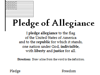
This printable handout includes the Pledge of Allegiance. Match each word with the definition: Pledge, Allegiance, Republic, Indivisible, Liberty, Justice.
Reading comprehension and vocabulary building.
Introduce your learners to the U.S. state of Connecticut with this printable handout of two worksheets (plus answer key). Your students will read a brief overview of Connecticut (location, capital, flag, state bird, state flower), write ‘Hartford’ next to the star on the map to show the location of the capital, color the small map, state bird and state flower, and use the map and compass to answer 10 true/false questions on page 2. Colored pencils and a pen or pencil are needed for this activity. No other prep needed. Basic Geography worksheet with a simple map to introduce the state of Connecticut and practice cardinal and ordinal directions.
For use with Interactive Notebooks: After the worksheets are completed, students can cut out the map, flag, state bird and state flower of Connecticut and paste into the notebook under the topic of United States/Sub-Topic: Connecticut. Under the map, students can write a summary in their own words of what they now know about this state. Collect worksheets for other states of the US to add to the notebook! Please browse this store for a selection of worksheets for other states of the USA (and beyond!).
Thank you so much for using my worksheets in your classroom! Reviews are welcome and very much appreciated!
Included: Rhode Island, Massachusetts, New York, Long Island, Long Island Sound, 13 original colonies, 1636, Bridgeport, American Robin, Mountain-laurel.
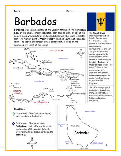
Introduce your learners to BARBADOS with two printable worksheets (plus answer key). Simple map activity and reading comprehension activity. No prep needed. Print and go!
Your students will read a brief introduction to Barbados (location, capital, flag, language), write ‘Bridgetown’ next to the star on the map to show the location of the capital, color the map, and use the reading passage, maps and compass to answer 10 true/false questions on page 2. Colored pencils and a pen or pencil are needed for this activity. No other prep needed. Basic Geography worksheet with a simple map to introduce Barbados and practice cardinal and ordinal directions.
For use with Interactive Notebooks: After the worksheets are completed, students can cut out the map and flag and paste into the notebook under the topic of (example) The Caribbean / Sub-topic: Barbados. Under the map, your students can write a summary in their own words of what they now know about Barbados. Collect worksheets of other countries of the Caribbean to add to the notebook! All available in this store!
Thank you so much for using my Geography worksheets in your classroom! I hope you find them useful. Reviews are welcome and very much appreciated. Please browse this store for more printable handouts with simple maps to introduce your learners to the countries of the world!
Sped, homeschool, homework, resource room teacher, independent learning, elementary, primary.
Included: Lesser Antilles, Mount Hillaby.
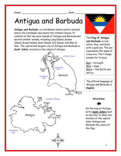
Introduce your learners to Antigua and Barbuda with two printable worksheets (plus answer key). Simple map activity and reading comprehension questions. Your students will read a brief introduction to Antigua and Barbuda (location, capital, flag, language), write ‘Saint John’s’ next to the star on the map to show the location of the capital, color the map, and use the reading passage, maps and compass to answer 10 true/false questions on page 2. Colored pencils and a pen or pencil are needed for this activity. No other prep needed. Basic Geography worksheet with a simple map to introduce Antigua and Barbuda and practice cardinal and ordinal directions. Print and Go!
For use with Interactive Notebooks: After the worksheets are completed, students can cut out the map and flag and paste into the notebook under the topic of (example) The Caribbean / Sub-topic: Antigua and Barbuda. Under the map, your students can write a summary in their own words of what they now know about this country. Collect worksheets of other countries of the Caribbean to add to the notebook! All available in this store!
Thank you so much for using my Geography worksheets in your classroom. I hope you find them useful. Reviews are welcome and very much appreciated!
SPED, Resource Room Teacher, Primary school, elementary
Introduce your learners to the island country of Vanuatu in Oceania with two worksheets (plus answer key). Your students will read a brief introduction to Vanuatu (location, capital, flag, islands, language), write ‘Port Vila’ next to the star on the map to show the location of the capital, color the small map, and use the map and compass to answer 10 true/false questions on page 2. Colored pencils and a pen or pencil are needed for this activity. No other prep needed. Basic Geography worksheet with a simple map to introduce Vanuatu and practice cardinal and ordinal directions.
For use with Interactive Notebooks: After the worksheets are completed, students can cut out the map and flag and paste into the notebook under Oceania/Sub-Topic: Vanuatu. Under the map and flag, students can write a summary in their own words of what they now know about this country. Collect worksheets for other countries of Oceania to add to the notebook! Please browse this store for worksheets for other countries of Oceania (and beyond!).
Thank you so much for using my Geography worksheets in your classroom! I hope you find them useful. Reviews are welcome and very much appreciated!
Pacific Ocean, Mount Tabwemasana, Espiritu Santo, Efate, Malakula.
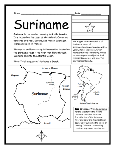
Introduce your students to Suriname, the smallest country in South America, with this black & white printable handout of two worksheets (plus answer key). Your students will read a brief introduction to Suriname (location, capital, flag, language), write ‘Paramaribo’ next to the star on the map to show the location of the capital, color the map and flag, and use the map and compass to answer 6 questions on page 2. Colored pencils and a pen or pencil are needed for this activity. No other prep needed. Basic Geography worksheet with a simple map to introduce the country of Suriname and practice cardinal and ordinal directions.
Please note this worksheet prints in black and white… (1) For easy printing, and (2) so students can do all of the the coloring! For more worksheets in black in white (or color) to introduce your learners to countries of South America and around the world, please browse this store!
Thank you so much for using this worksheet in your classroom! Reviews are welcome and very much appreciated.
Introduce your students to the country of SAN MARINO with two worksheets (plus answer key). Your students will read a brief introduction to San Marino (location, capital, flag, language), write ‘City of San Marino’ next to the star on the map to show the location of the capital, color the small map, and use the map and compass to answer 6 multiple-choice questions on page 2. Colored pencils and a pen or pencil are needed for this activity. No other prep needed. Basic Geography worksheet with a simple map to introduce the country of San Marino and practice cardinal and ordinal directions.
For use with Interactive Notebooks: After completing the worksheets, students can cut out the map and flag and paste into the notebook under the topic of Europe/Sub-Topic: San Marino. Under the map and flag, students can write a summary in their own words of what they now know about this country. Collect worksheets for other countries of Europe to add to the notebook! Please browse this store for the list of worksheets for other countries of Europe (and beyond!).
Thank you so much for using my Geography worksheets in your classroom! I hope you find them useful. Reviews are welcome and very much appreciated.
Introduce your learners to Bear Lake on the border of Idaho and Utah in the United States with this printable handout of two worksheets (plus answer key). Your students will read a brief overview of Bear Lake, trace the line to separate Idaho and Utah, color the small map, and use the map and compass to answer 7 True/False questions on page 2. Colored pencils and a pen or pencil are needed for this activity. No other prep needed. Basic Geography worksheet with a simple map to introduce Bear Lake and practice cardinal and ordinal directions.
Also available:
IDAHO - Printable worksheet with map and flag
UTAH - Printable worksheet with map and flag
For use with Interactive Notebooks: After the worksheets are completed, students can cut out the map of Bear Lake and paste into the notebook under the topic of United States / Sub-Topic: Bear Lake. Under the map, students can write a summary in their own words of what they now know about Bear Lake. Collect worksheets for states of the US and more to add to the notebook! Please browse this store for a selection of printable worksheets for other states of the USA and more!
Thank you so much for using my worksheets in your classroom! Reviews are welcome and very much appreciated!
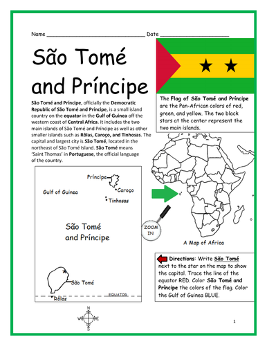
Introduce your students to the island country of São Tomé and Príncipe in Africa with two worksheets (plus answer key). Your students will read a brief introduction to São Tomé and Príncipe (location, capital, flag, language), write ‘São Tomé’ next to the star on the map to show the location of the capital, trace the line of the equator, color the small map, and use the map and compass to answer 8 questions on page 2. Colored pencils and a pen or pencil are needed for this activity. No other prep needed. Basic Geography worksheet with a simple map to introduce São Tomé and Príncipe and practice cardinal and ordinal directions.
For use with Interactive Notebooks: After the worksheets are completed, students can cut out the map and flag and paste into the notebook under the topic of Africa/Sub-topic: São Tomé and Príncipe. Under the map and flag, your students can write a summary in their own words of what they now know about this country. Collect worksheets for other countries of Africa to add to the notebook! Please browse this store for worksheets for other countries of Africa (and beyond!)
Thank you so much for using my Geography worksheets in your classroom! I hope you find them useful. Reviews are welcome and very much appreciated.
Rôlas, Caroço, Tinhosas, Portuguese
Introduce your students to Spain with two worksheets (plus answer key). Your students will read a brief introduction to Spain (location, capital, flag, language), write ‘Madrid’ next to the star on the map to show the location of the capital, color the flag and map, and use the map and compass to answer 7 questions on page 2. Colored pencils and a pen or pencil are needed for this activity. No other prep needed. Basic Geography worksheet includes a simple map to introduce Spain and practice cardinal/ordinal directions.
For use with Interactive Notebooks: After completing the worksheets, students can cut out the map and flag and paste into the notebook under the topic of Europe (or Spanish-Speaking Countries), Sub-Topic: Spain. Under the map and flag, students can write a summary in their own words of what they now know about this country. Collect worksheets for other countries of Europe to add to the notebook! Please browse this store for a selection of worksheets for other countries of Europe (and beyond!).
Thank you so much for using my worksheets in your classroom! I hope you find them useful. Reviews are welcome and very much appreciated.
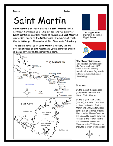
Introduce your learners to the island of Saint Martin with two printable worksheets (plus answer key). Simple map activity and reading comprehension questions. Print and Go!
Your students will read a brief introduction to Saint Martin (location, capital, flag, language), locate and circle the island of Saint Martin on the map of the Caribbean (map 1), trace the dotted line on the map of Saint Martin (map 2) to show the border of Saint Martin (an overseas region of France) and Sint Maarten (an overseas region of the Netherlands), write ‘Marigot’ next to the star on the map of Saint Martin to show the location of the capital, write ‘Philipsburg’ next to the star on the map of Sint Maarten to show the location of the capital, and use the reading passage, maps and compass to answer 9 true/false questions on page 2.
For use with Interactive Notebooks: After the worksheets are completed, students can cut out the map and flags and paste into the notebook under the topic of (example) The Caribbean / Sub-topic: Saint Martin. Under the map, your students can write a summary in their own words of what they now know about this island. Collect worksheets of other countries of the Caribbean to add to the notebook! All available in this store!
Thank you so much for using my Geography worksheets in your classroom! I hope you find them useful. Reviews are welcome and very much appreciated! Please browse this store for more printable worksheets with simple maps to introduce your students to the countries of the world!
Printable Handout (1 page plus answer key) ‘A Summer Day at the Beach.’ Students will fill in the blanks using the word bank of past-tense verbs: parked, swam, collected, drove, decided, watched, walked, sat, read, ate, packed, carried.
Cloze activity for ESL, EFL, ELL, ESOL. Vocabulary building, Reading Comprehension, Grammar.
Introduce your students to the 7 continents with this printable handout of 2 worksheets (plus answer key). Your students will write the name of each continent on the map: Africa, Antarctica, Asia, Europe, North America, Oceania (Australia), and South America, trace the line of the equator, color the small map, and use the map and compass to answer 7 questions. Colored pencils and a pen or pencil are needed for this activity. No other prep needed. Basic geography worksheet with a simple map to introduce the continents and practice cardinal and ordinal directions.
For use with Interactive Notebooks: After the handout is completed, students can cut out the map of the 7 continents and paste into the notebook. Under the map, students can write a summary in their own words of what they now know about the continents. Collect handouts for countries of Africa, Antarctica, Asia, Europe, North America, Oceania/Australia, and South America to add to the notebook! Please browse this store for a selection of printable handouts.
Thank you so much for using my Geography worksheets in your classroom! I hope you find them useful!
Introduce your students to NEW ZEALAND with this printable handout of two worksheets (plus answer key). Your students will read a brief overview of New Zealand (location, capital, flag, language), write ‘Wellington’ next to the star on the map to show the capital, color the small map, and use the map and compass to answer 7 questions. Colored pencils and a pen or pencil are needed for this activity. Basic Geography worksheet with a simple map to introduce New Zealand and practice cardinal and ordinal directions.
For use with Interactive Notebooks: After the handout is completed, students can cut out the map and flag of New Zealand and paste into the notebook. Under the map and flag, students can write a summary in their own words of what they now know about New Zealand. Collect handouts for other countries to add to the notebook. Please check out my store for a selection of worksheets for other countries!
Thank you so much for using my Geography worksheets in your classroom. I hope you find them useful. Reviews are welcome and very much appreciated! Happy Teaching!
Included: Auckland, North Island, South Island, Cook Strait, Stewart Island, Pacific Ocean, Tasman Sea.